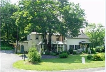
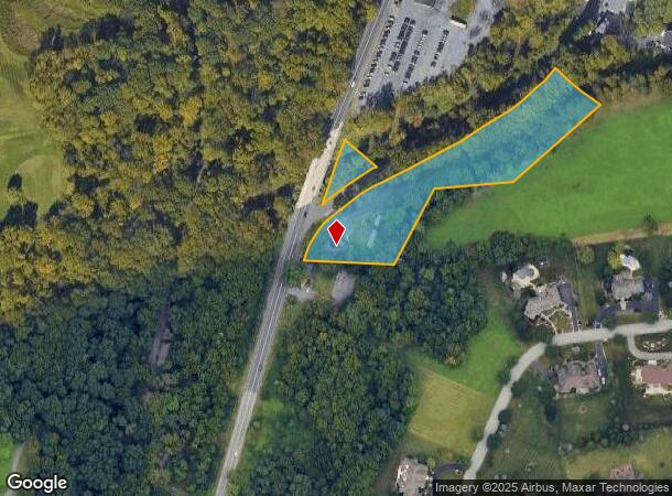
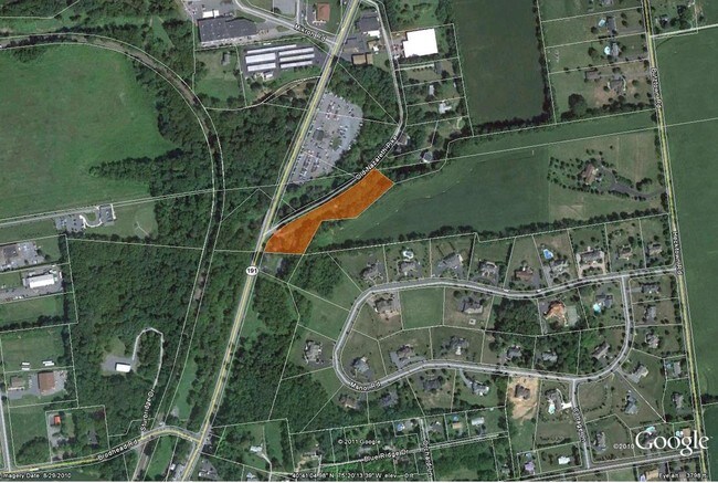
Property Record
4266 Nazareth Pike, Bethlehem, PA 18020
NEARBY LISTINGS FOR SALE OR LEASE
Property Detail
4266 Nazareth Pike
L7-11-4A-0205
Subdivision Plan Residence Building For
Commercialofficeresidentialmixeduse
Northampton
AE
Pennsylvania
42095C0262E
2.79 AC
2025
Lehigh Valley
2025
Philadelphia
017605
Allentown-Bethlehem-Easton, PA-NJ
3,484 SF
DEMOGRAPHICS near 4266 Nazareth Pike
1 Mile
3 Mile
5 Mile
2024 Total Population
3,350
38,262
134,489
2029 Population
3,349
38,493
135,412
Pop Growth 2024-2029
(0.03%)
+ 0.60%
+ 0.69%
Average Age
45
43
43
2024 Total Households
1,203
14,159
52,781
HH Growth 2024-2029
(0.17%)
+ 0.54%
+ 0.64%
Median Household Inc
$116,717
$102,540
$85,999
Avg Household Size
2.60
2.60
2.40
2024 Avg HH Vehicles
2.00
2.00
2.00
Median Home Value
$352,570
$302,071
$271,715
Median Year Built
1983
1984
1972
Nearby Places
Map Layers
Map Styles
 Street
 Aerial
- Restaurants
- Banks
- Shops
- Fitness
- Groceries
PUBLIC TRANSPORTATION
AIRPORT
Lehigh Valley International
DRIVE
WALK
Distance
Lehigh Valley International
13 min
7.4 mi
Freight Ports
Port of Philadelphia
DRIVE
WALK
Distance
Port of Philadelphia
97 min
72.5 mi
Nearby Properties
Address
Land Use
TOTAL SIZE
Lot Size
Zoning
Address
Land Use
TOTAL SIZE
Lot Size
Zoning
605,906 SF
94.28 AC
A
Address
Land Use
TOTAL SIZE
Lot Size
Zoning
302,378 SF
83.53 AC
A
Address
Land Use
TOTAL SIZE
Lot Size
Zoning
82.80 AC
I2
Address
Land Use
TOTAL SIZE
Lot Size
Zoning
276,484 SF
31.19 AC
A
Address
Land Use
TOTAL SIZE
Lot Size
Zoning
52,164 SF
124.81 AC
IN
Address
Land Use
TOTAL SIZE
Lot Size
Zoning
298,660 SF
37.43 AC
PIBD
Address
Land Use
TOTAL SIZE
Lot Size
Zoning
524,948 SF
35.66 AC
LI
Address
Land Use
TOTAL SIZE
Lot Size
Zoning
249,872 SF
41.83 AC
PC
Address
Land Use
TOTAL SIZE
Lot Size
Zoning
319,788 SF
60 AC
IN
Address
Land Use
TOTAL SIZE
Lot Size
Zoning
512,902 SF
35.18 AC
LI
Address
Land Use
TOTAL SIZE
Lot Size
Zoning
601,903 SF
41.68 AC
LI
Address
Land Use
TOTAL SIZE
Lot Size
Zoning
42,465 SF
7.28 AC
LI
Address
Land Use
TOTAL SIZE
Lot Size
Zoning
539,133 SF
47 AC
LI
Address
Land Use
TOTAL SIZE
Lot Size
Zoning
1,456 SF
29.36 AC
A
Address
Land Use
TOTAL SIZE
Lot Size
Zoning
508,835 SF
34.92 AC
A
Address
Land Use
TOTAL SIZE
Lot Size
Zoning
208,053 SF
45.58 AC
I
Address
Land Use
TOTAL SIZE
Lot Size
Zoning
244,478 SF
26.32 AC
LI
Address
Land Use
TOTAL SIZE
Lot Size
Zoning
307,425 SF
37.13 AC
A
Address
Land Use
TOTAL SIZE
Lot Size
Zoning
430,201 SF
17.30 AC
I
Address
Land Use
TOTAL SIZE
Lot Size
Zoning
109,753 SF
15.33 AC
PIBD
Address
Land Use
TOTAL SIZE
Lot Size
Zoning
294,412 SF
28.72 AC
A
Address
Land Use
TOTAL SIZE
Lot Size
Zoning
284,079 SF
20.65 AC
A
Address
Land Use
TOTAL SIZE
Lot Size
Zoning
257,186 SF
14.63 AC
G1
Address
Land Use
TOTAL SIZE
Lot Size
Zoning
201,145 SF
37.93 AC
LI
Address
Land Use
TOTAL SIZE
Lot Size
Zoning
120,359 SF
22.49 AC
R1S
Address
Land Use
TOTAL SIZE
Lot Size
Zoning
229,448 SF
12.95 AC
GI
Address
Land Use
TOTAL SIZE
Lot Size
Zoning
312,950 SF
33.17 AC
A
Address
Land Use
TOTAL SIZE
Lot Size
Zoning
152,352 SF
17.18 AC
IN
Address
Land Use
TOTAL SIZE
Lot Size
Zoning
227,807 SF
12.09 AC
GI
Address
Land Use
TOTAL SIZE
Lot Size
Zoning
22,752 SF
10.17 AC
MHDR
The World's #1 Commercial Real Estate Marketplace
Connect with us
© 2025 CoStar Group
The information above has been obtained from sources believed reliable. While we do not doubt its accuracy we have not verified it and make no guarantee, warranty or representation about it. It is your responsibility to independently confirm its accuracy and completeness. Any projections, opinions, assumptions, or estimates used are for example only and do not represent the current or future performance of the property. The value of this transaction to you depends on tax and other factors which should be evaluated by your tax, financial, and legal advisors. You and your advisors should conduct a careful, independent investigation of the property to determine to your satisfaction the suitability of the property for your needs.